
Uses of BIM on site: 4D Planning, As-Built Modelling

Below, Rodrigo Sánchez del Río, an alumnus of the International Master’s in BIM Management, presents a list of some of the most common uses in practice, inspired by the “BIM Project Execution Planning Guide” document from Pennsylvania State University, developed in Chapter Two “Identifying Project Objectives and BIM Uses” and Appendix B “Description of BIM Uses.” It will focus on the following topics:
- The fourth and fifth dimensions of BIM, namely time and costs
- Design review and interference detection
- Planning the implementation of the work
- “As-Built” modeling and entering execution information into the model
For this study, Autodesk Navisworks software was used. While it lacks some features to be a “definitive control console” for the project, it comes pretty close. It’s worth noting that mastery of 3D digital modeling isn’t required to use this or other similar software. In fact, many designers won’t submit their models in their native format (due to the risk of information corruption, copyright issues, and other issues), but rather the file will likely be in IFC format, the standard language for BIM information exchange. What is necessary to verify is that the modeling is done according to certain criteria:
- Elements must be presented according to a construction criterion. For example, a column cannot be modeled as a continuum from the first to the last floor, as it is not feasible to execute it on-site in this manner. Furthermore, with prior agreement with the construction team, the elements must be organized into batches or construction units. A clear example is slabs, which can sometimes cover large areas and require construction in several stages.
- Depending on the level of detail required for planning, certain composite elements such as walls can present difficulties. Masonry and finishes should be entered separately to reflect the reality of the project; however, this can require significant work for modelers and, in certain cases, will require more than one model for the project, breaking down one of the paradigms surrounding BIM implementation: the existence of a single model for all phases of the project lifecycle.
- While not essential (given the capabilities of construction management software), it is beneficial for the model to be organized into element packages for its execution, whether through parameters or selection sets (an example of classification could be column types – circular, rectangular, or screens).
4D Planning and Design of Construction Processes (Virtual Construction Simulation)
Also known as the fourth dimension of BIM (time), this approach involves linking the 3D model to a physical schedule to obtain a complete or partial simulation of the construction processes. In Navisworks, it’s very easy to link a model to a schedule, whether it’s Microsoft Project, Primavera, or a simple text list in CSV format. This can be done manually, by creating selection sets, or by automatically programming rules.Simulation can be used prior to the start of work, detecting potential conflicts between tasks and specific needs (such as equipment) or for monitoring work as shown in Figure 1, where we see in a screenshot the huge difference that a foreman can make when viewing a cumbersome Gantt chart, compared to a 3D representation of the work, which not only gives a more global view of the project but also helps to detect discrepancies more clearly.
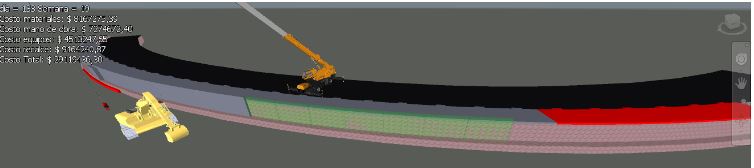
Figure 1. Construction monitoring simulationAnother very interesting application of simulations is the detection of risks in tasks, among other things, to develop Safety Studies and Plans for the construction site. For example, Figure 2 shows a concrete filling task with a pump. At first glance, several associated risks can be identified, such as falls from heights, machinery overturning, falling objects, accidents, or collisions, among others. They can also be used to define contingency plans and meeting points within the construction site.
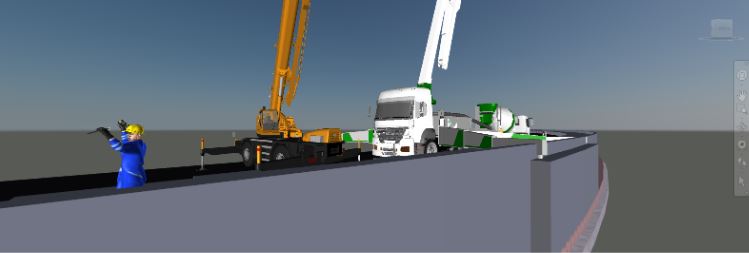
Figure 2. Simulation of the filling process with a concrete pump
Cost estimation and monitoring
The role of the BIM model in cost estimating (also known as the fifth dimension of BIM) lies in automatically obtaining quantities from the geometric parameters of the components. This can be implemented in several ways, either within modeling software or by linking the model to other budgeting-specific platforms.Navisworks offers a quantity extraction module, which, interestingly, works independently within the program. The information is exported to Microsoft Excel pivot tables, from which you can further process the data to calculate your budget.
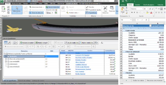
Figure 3. Quantity extraction module interfaceCost tracking during construction is not yet fully developed (in terms of information automation). Few software programs achieve a true combination of 4D planning and the costs generated at this stage, and those that do may not offer sufficient flexibility in the format we want for our lists.
Design review and interference detectionWhile these procedures are addressed during the design phase, it’s good practice for the project’s technical team to review them for a second time. Navisworks is a very powerful tool in this regard, generating comprehensive reports in Microsoft Excel spreadsheet format that can be shared with the design team.
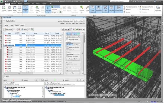
Figure 4. Collision detection in NavisworksAnother form of information exchange that is gaining momentum is the BIM Collab system. This is a role-based structure that operates in the cloud and allows participants to exchange information in BCF format files. These files contain, in addition to snapshots with incident views, metadata regarding the person responsible for correcting the issue, processing status, and other information. Currently, several software programs have a direct connection to this platform through plug-ins (in the case of Navisworks, BCF Manager).
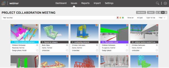
Figure 5. BIM Collab Platform Interface
Planning the implementation of the work
One of the key issues in planning any construction project is the definition and layout of the spaces that will serve as temporary storage facilities for materials and equipment, staff welfare services, and the technical management offices. These spaces must be functional enough to allow for efficient work without negatively impacting the environment.Incorporating these structures into the BIM model is extremely beneficial. Navisworks offers a kmz export option for realistic visualization of the facilities in Google Earth. This tool is especially powerful for assessing the proximity of the project to key points (such as nearby towns, gas stations, police stations, etc.) and potential environmental impact sites (such as waterways).
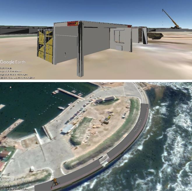
Figure 6. 3D model imported into Google Earth
As-Built Modeling
This use would be equivalent to creating “as-built” drawings, except that in this case, what is updated is a 3D model. And the most interesting thing is that not only is the geometry updated (a task that can be performed by a modeler), but data associated with each element is also entered, and this is where the role of the construction manager becomes important. All types of information can be entered, for example, quality control and material receipt data, daily reports with specific incidents, labor and material consumption, among many others, are useful.Navisworks offers the ability to link the model to external databases through a module called Data Tools, which uses ODBC drivers for connection and SQL programming for data extraction. The most commonly used databases are Excel spreadsheets; however, any type of data can be connected as long as the correct driver is available and the configuration and programming are performed appropriately.
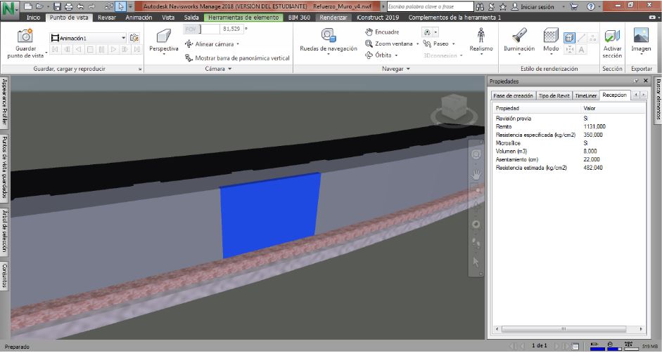
Figure 7. Concrete reception data associated with a 3D model elementAnother powerful application is creating color filters to visualize certain parameters. For example, Figure 8 shows a color code corresponding to different labor performance values. This, like simulations, gives middle management (engineers, foremen, and supervisors) a much clearer picture of the crew’s status and allows for faster and more intuitive decision-making.On the other hand, data management in Navisworks is limited to data visualization. Although the data entry system is very powerful, it cannot be edited (except through the plug-in add-on) and offers few export formats (mostly CSV).Final Thoughts and the Last Planner SystemThe use of BIM is advancing steadily in Latin America, and Uruguay is beginning to adopt it as part of everyday industry practice. In May 2019, the CSI Ingenieros firm published a document on the Diagnostic of the BIM Situation in Uruguay, which yielded very important results. While the level of use is respectable among the professionals surveyed (approximately a third), one result stands out significantly: the collaborative and interdisciplinary use of BIM is almost nonexistent.
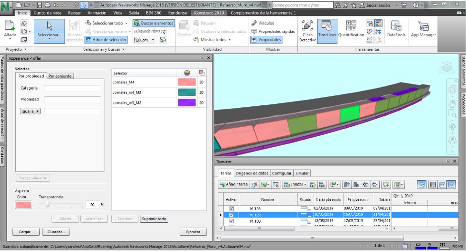
Figure 8. Color filters for performance visualizationIn other words, BIM is implemented as a technological upgrade, but collaboration between the various project stakeholders is neglected. This is perhaps the most important aspect of the methodology, and it plays a key role in the execution of a project.To understand the true relevance of BIM in a construction project, it’s worth looking at the management system developed by Glenn Ballard, called the “Last Planner” (LPS), which is defined as the foreman or construction manager, that is, the person who directly assigns tasks to workers.This is a proactive system, not a reactive one like traditional construction. Viewing the life cycle of a project like the course of a river, the activities of upstream actors (designers, surveyors, budgeters) push production toward downstream activities (construction), generating risks of schedule delays, cost overruns, and other issues.In this model, all stakeholders work together, located as close to the construction site as possible. Planning is carried out in advance (identifying design and construction issues before the project is executed), with a joint commitment from all parties (everyone assumes a share of the project risk, not just those executing it). Weekly project scaffolding plans are developed and reviewed, capturing lessons learned from unfulfilled commitments.But what does this have to do with BIM? The virtual model is a perfect complement to the method, integrating all stakeholders to collaborate during the design and construction stages. The knowledge input of the final planner will enrich the model’s information and make it more reliable and safe to build.


