BIM Experience of SENER in Infrastructure Work Projects

SENER is a multidisciplinary engineering firm with a clear commitment to innovation, a tenet that has been part of the company’s DNA since its founding in 1956. In the area of civil engineering,
SENER first encountered BIM in 2006, when it began working with a modeling program for the development of the Sagrera station in Barcelona. SENER specializes in transportation infrastructure such as railway and metro lines, roads, and buildings such as stations and airports.
To this end, the SENER BIM Office was created
, a working group comprised of specialists from all disciplines whose mission is to establish tools and processes so that all project participants can contribute and receive value. In recent years, the company has specialized in implementing BIM solutions within the linear construction sector.
The use of BIM in the field of geotechnics and tunnels
Within the civil and architectural division is the geotechnical and tunneling discipline. For several years,
SENER has been working on the progressive implementation of the BIM work methodology. To this end, resources are being allocated to the development of tools, workflows, and task automation, focusing these efforts on building full coordination of work within this discipline and the other parties involved in a linear infrastructure project.
To carry out this ambitious project,
SENER has developed an internal tool that provides geotechnical information in the BIM model of any infrastructure project. This software is capable of generating BIM models from the geological and geotechnical information collected in field surveys conducted throughout the project’s lifecycle. 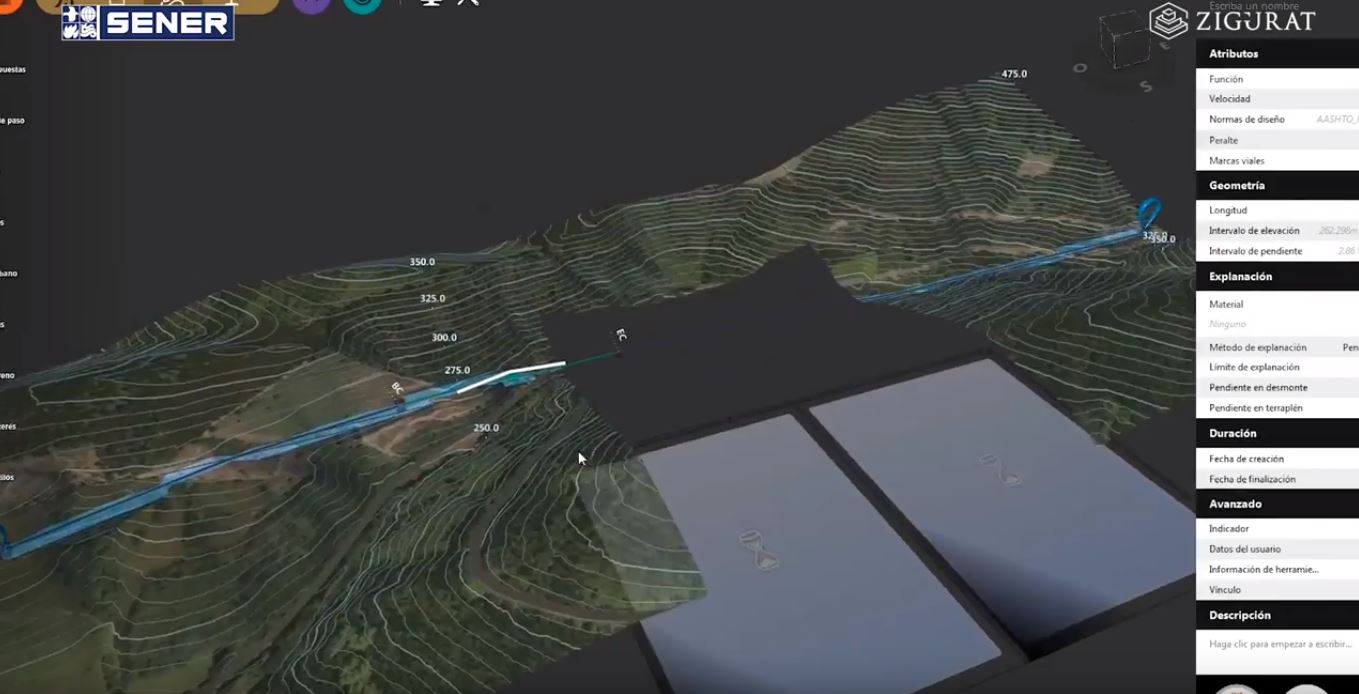
Image source: SENER
This information is implemented in the software using CSV files.
SENER’s tool addresses the need for a suitable working environment for obtaining a reliable three-dimensional geological model. This is a requirement that was not met by the software packages currently on the market. The application’s main feature is that it integrates the geologist’s interpretation and knowledge into the BIM model generation process.
Using traditional data input, the software provides graphical and analytical tools that allow you to define the different layers along the layout. From the generated BIM model, the rest of the discipline will be able to graphically view the information associated with each layer for use in the calculation and design processes.
The use of BIM for railway and road infrastructure
The railway and road infrastructure sector is also working on implementing the BIM methodology from the conceptual design phase of a project.
Its application from the initial stage allows for a comprehensive analysis, enabling us to find the optimal solution and improve the quality of the work performed.
The applied workflow enables something fundamental to the BIM philosophy: collaboration among all disciplines involved in the project.
BIM tools allow for simultaneous plan and elevation designs, providing an integrated corridor model directly on screen with the obvious advantage of being able to make corrections in real time.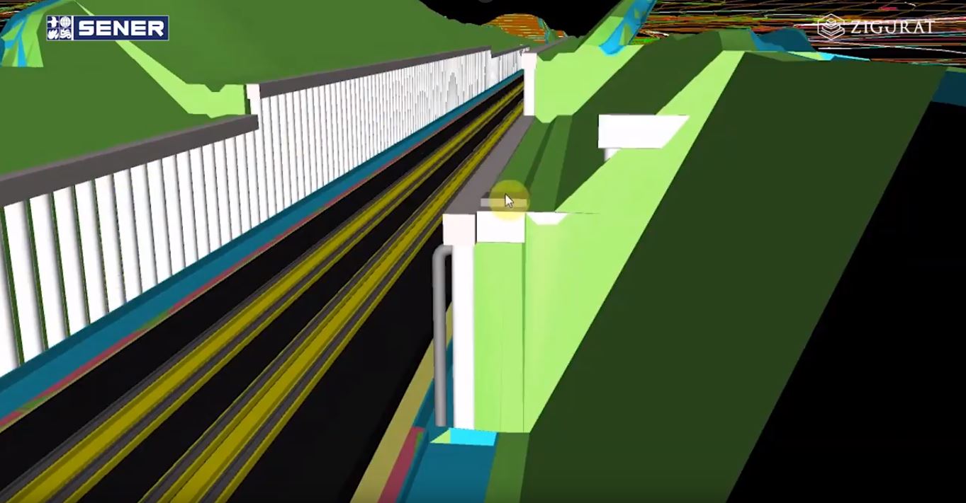
Image source: SENER
The implementation of unique elements such as tunnels, viaducts, and drainage systems is carried out quickly and efficiently, with the possibility of adapting and modifying types in real time.
This approach allows SENER to make both economic and technical decisions when selecting the most viable alternatives. The work carried out during this project phase can be transferred to subsequent levels and can therefore be reused, adapting or improving it to the specific characteristics of subsequent stages. The three-dimensional view of the project and the changes made in real time provide added value, significantly improving decision-making and the quality of the projected solution.
Advantages of BIM implementation
The use of this methodology
has provided the SENER team with significant benefits, including increased product quality, a significant reduction in coordination errors, and improved project drafting follow-up.
Using BIM allows you to create a virtual model of the project. From this model, you can analyze the elements that comprise the project, both individually and in a coordinated manner. You can check their interaction with the environment, detect geometric coordination errors, and, most importantly, obtain an informed model to which you can add virtually any information. This translates into greater project control and, therefore, a significant improvement in quality. 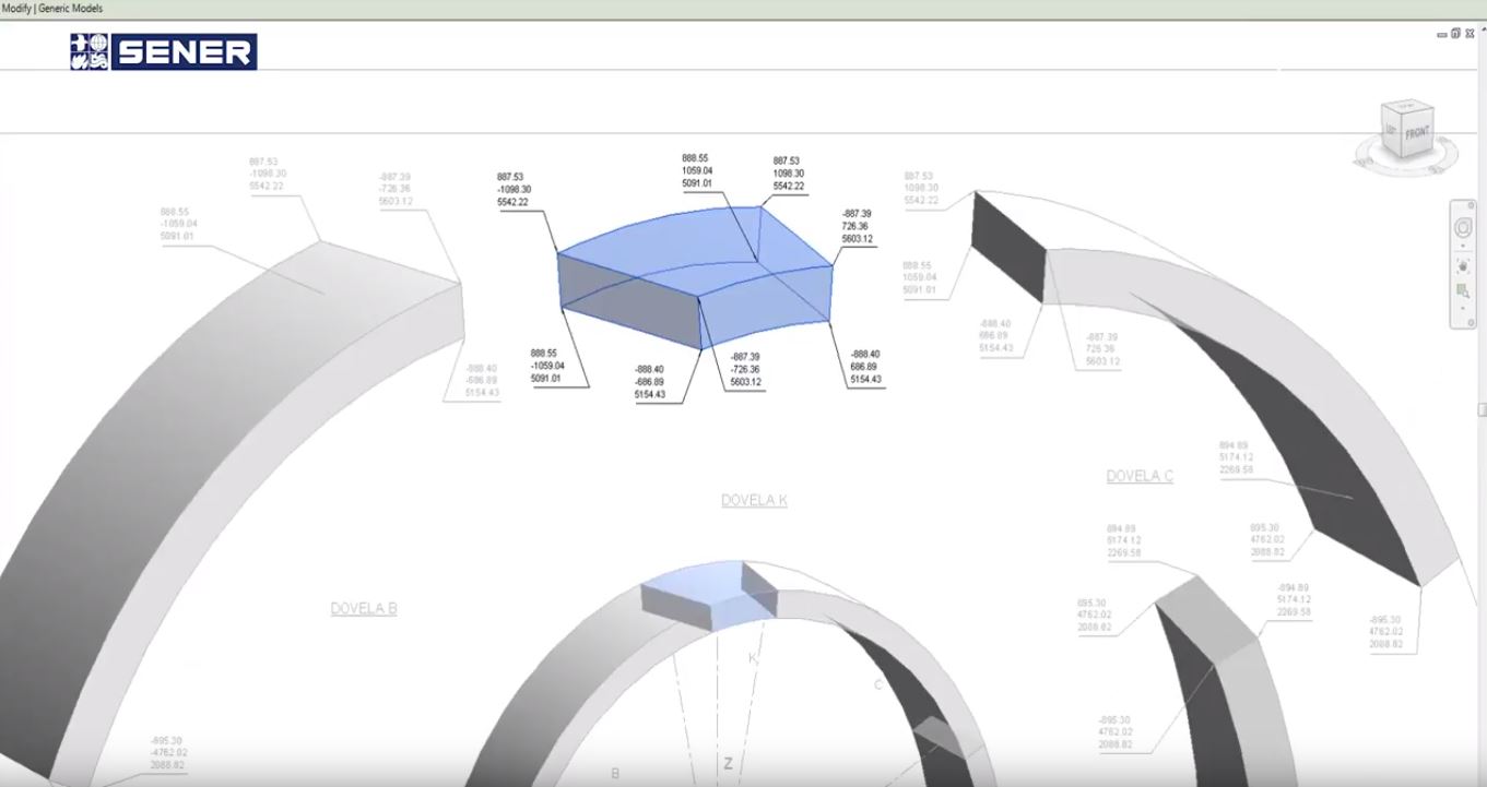
Image source: SENER
SENER has leveraged several major projects, such as Line 3 of the Guadalajara Metro, the Mexico-Toluca intercity train, the Santelmo-Jinamar line in Gran Canaria, and the tunnel under the Suez Canal, to implement BIM workflows and 3D structural modeling and design. These projects have improved the interaction and adaptation between the design phase and the subsequent construction, operation, and maintenance phases.