


From 3D scan to georeferenced BIM model
Implementation
Published by:
Datasheet
Description
Located in the 13th district, the site of the Lourcine barracks covers 24,900 m2 and includes 4 buildings. In 2015, the Epaurif decided to transform this site into a university campus for the Paris I Sorbonne University. As a general contractor for the project, Bouygues Bâtiment Ile-de-France Ouvrages Publics has been mandated to rehabilitate the two buildings dating from 1880, representing a total area of approximately 9,000 m2. In order to create a BIM model that retranscribes the architectural data as precisely and precisely as possible, Stéphane Hanich, project manager, called the surveyors' office, Alpes Topo.

Create a modeling chart
In a rehabilitation project, it is as essential to define the future uses of the BIM model as in a construction project. Before carrying out the 3D scan, the Alpes Topo teams were therefore careful to draft a modeling chart that meets the specifications.
"This basic step consists of describing the structuring of the model, indicating the levels, determining the objects (walls, floor, columns, etc.) that will be modeled and the parameters to be integrated for each object family, or to specify the conditions for 'exports of the data,' says Tristan Aurigny, in charge of deploying the BIM at Alpes Topo. During a rehabilitation operation, our model serves as a base for those of other project stakeholders. It must therefore integrate the level of detail to meet the needs of each. "
Note that according to the scan used, the clouds of points obtained can be more or less dense (every millimeter or more). Alpes Topo therefore defines upstream the tool adapted to the level of precision required.
Collect georefencered data
First stage of data acquisition: design a georeferenced repository. For this, the teams place on the site checkers and spheres serving as support for scans. Each contains planimetric and altimetric information and is located within the official French geographical reference frame. These marks also facilitate the assembly of the various scans carried out. "Preserved within the BIM model, this georeferencing allows integrating the building model into a GIS system presenting a site, a neighborhood or even a city ... since the other components of the model are also georeferenced. " , Says Tristan Alderney.
"Georeferencing has enabled buildings to be precisely positioned within the campus and vis-à-vis other buildings, networks and property boundaries," confirms Stéphane Hanich, project manager at Bouygues Bâtiment Île-de-France Public Works. This allowed us also to note some small differences between the architectural plans of the early XIX th century and reality. "
Once the scans are assembled, the teams ensure the accuracy of the coordinates and the cohesion of all the scans. Then, point clouds are "cleaned" of useless objects, such as furniture in a room for example.
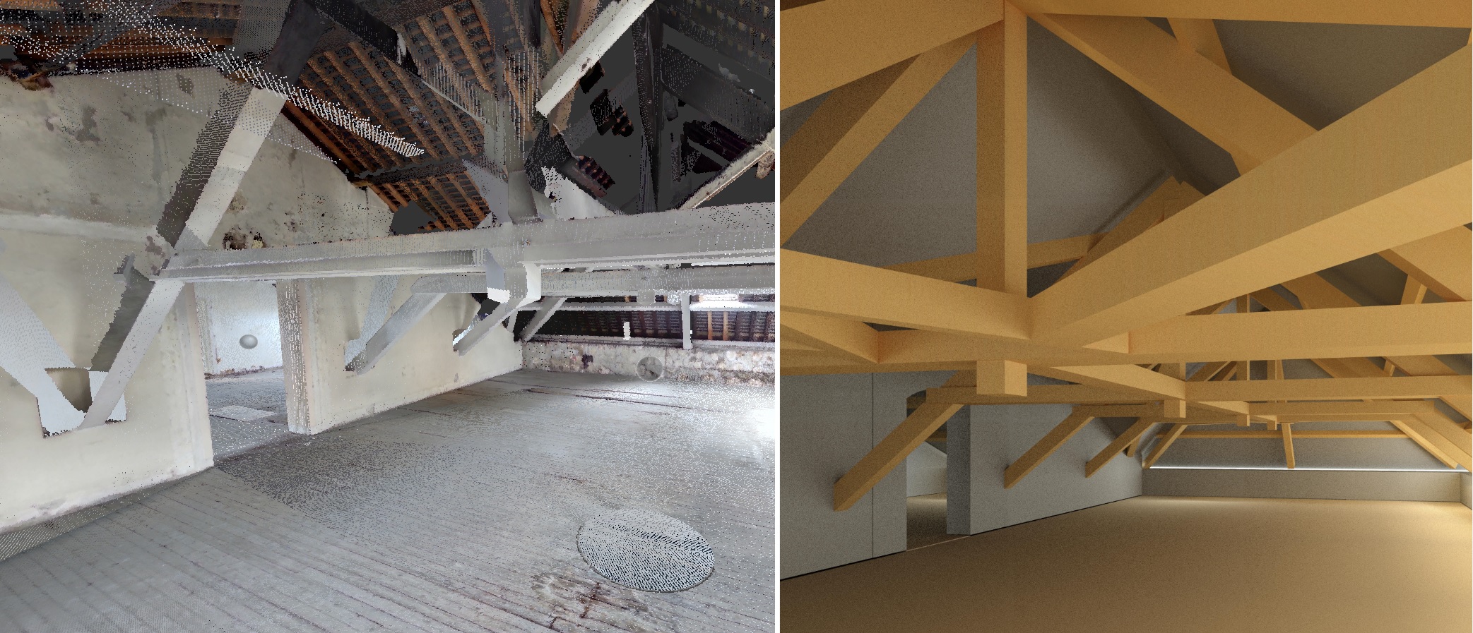
Model from a cloud of points
Next step: importing the complete point cloud into a BIM software. "It takes the form of a reference file which includes grids georeferenced building and elevation levels of the ground floor to the R + 4" , explains Tristan Alderney. Thanks to the knowledge of Alpes Topo's modeling teams, contractually defined objects (walls, columns, floors, etc.) are dimensioned and positioned precisely according to the point cloud. The teams then monitor the result and redraw the rest in accordance with the level of precision required in the modeling chart.
Then,"We perform a colorimetric analysis to verify that the modeled objects correspond to the point cloud. For each project, we provide the native format ET and IFC format, after making sure both understand the same information. In the sand of the exchanges with the architect, this one could correct some existing gaps between its objects and the reality established by the scans. " , Said the surveyor.
Why this IFC format? Stéphane Hanich answers: "The studies phase of the Lourcine construction site is carried out in Level 2 collaborative BIM. The various stakeholders, including the surveyor and the architect, import their model on the global server so that the BIM Manager can compile them. perform clash detection. So that everyone has a common language and can exchange in an interoperable way, we naturally chose the IFC format! "
The advantatges of a BIM model resulting from a georeferenced 3D scan
"This method offers accuracy and reliability that is very difficult to achieve in other ways. The deliverable is easily integrated into our 3D model and can detect clashes earlier and make more rigorous studies. It is an undeniable gain of time. Not to mention that the 3D scan can be viewed on the cloud in the form of a 360 ° photo in which we move. Whether for meetings in the study phase or for exploitation, it is a great communication tool. " Concludes Stéphane Hanich.
The georeferenced scan is still young and only the latest versions of some software can reproduce a georeferenced BIM model. But Tristan Alderney does not doubt that technology will develop.
Implementation sector
- Builders
Type of Implementation
Size of the company
- Big BIM
Actors leading the implementation
- Bottom-Up