


BIM and GIS for Smart Infrastructural Development
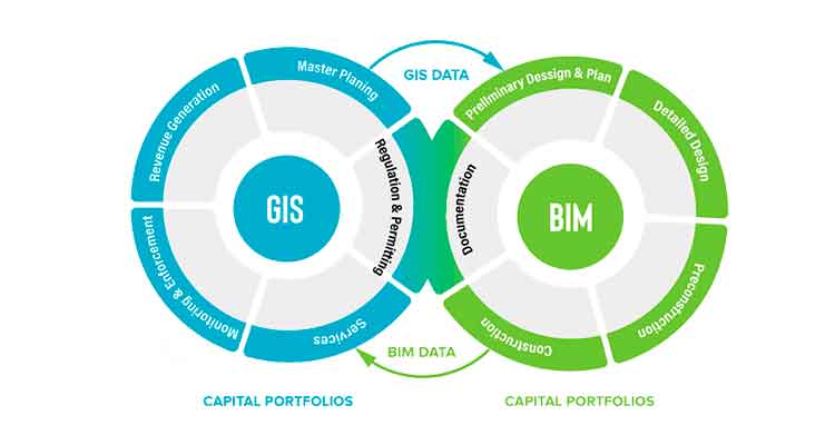

Building Information Modeling (BIM) and Geographic Information System (GIS) are set to transform smart infrastructural development. Be it for planning, design, construction and operation, the fusion of these two technologies provides a holistic view of the infrastructure. GIS informs BIM and in turn BIM fuels GIS. The process through which GIS informs BIM is by providing a real-life context of existing facility assets with engineers and designers, leaving more scope for design exploration and evaluation. Subsequently, BIM fuels GIS through accurate model creation, enhancing facility operations and asset maintenance of a large construction.
How BIM and GIS Integration Help AEC Professionals?
· Positioning Infrastructure in the Context of Surroundings: Geographic Information System data places infrastructure like railways, airports, roads, bridges, etc in the right context as per the surroundings. While GIS helps AEC stakeholders understand how to put infrastructure in a context, Building Information Modeling information acts as a vital aspect of the design-build process of that infrastructure. The process of BIM and Geographic Information System integration blends the BIM model into several layers of geospatial context. As a result of which the designers use GIS for deriving accurate information about an area where construction would take place. To take an instance, if an area for construction is prone to flooding, designers get to learn about it from the GIS data and consequently inform the building owners about the required materials, orientation and location of the structure. GIS information is applied to cities, regions and countries, whereas BIM is tied to the design and construction of a structure. Geographic Information System makes the whole picture bigger in a smarter and larger environment context, becoming a part of utilities, roads and land.
· Smart Urban Planning and Management: To address the macro-economic challenges and create sustainable and resilient infrastructure, seamless data sharing is the key to successful BIM design. GIS BIM integration breaks down all obstacles to enhance urban planning and management.
· Saving Costs & Making Efficient Design Decisions: Irrespective of the contractors’ goal, for scaling the entire work process to factory-level prefabrication, reducing data loss and time as well as for improving logistics, scheduling becomes the main concern. Using Building Information Modeling and Geographic Information System, new spatial elements are integrated into an innovative construction workflow to enhance the efficacy of the design and construction.
Governance Model for Successful Smart Cities & BIM Integrated GIS Effectiveness: As per SBA reports, 44% of U.S. economic activity comes from small businesses tied to a community. Major PWC report stated that New York, Singapore and Boston are the cities that proactively planned associations between businesses and citizens to stimulate growth and improve social outcomes. Common features of smart city design include good health, prosperity, social bonds, security and purpose. BIM integrated GIS has the potential to provide all these aspects for the wellness of the community through accurate GIS data and BIM modeling.
Applications of BIM integrated GIS:
1. 3D Visualization—BIM and GIS have the ability to provide insight into the current state, and urgent issues using analytics, big data, machine learning, and artificial intelligence.
2. Design Creation—Software tools like Dynamo integrated with accurate geospatial data and machine learning technology facilitate in creating beautiful and cost-effective building designs.
3. Data Requirement for Smart Communities – Construction professionals investigating BIM-GIS technology realize a streamlined flow of information between the operational and construction life cycle.
What’s next for BIM and GIS?
It’s already clear that Building Information Modeling and Geographic Information Systems have the potential for building smarter cities. If the two technologies are merged, AEC project stakeholders could have better collaboration with software vendors. Local governments, as well as asset management companies, should set up their BIM specifications at an early stage of the design-build process for later usage during facility operations and management. Major urban areas need to create multiple standards across utilities, transportation and architectural projects. A model of the information flow should be developed by the AEC project stakeholder and BIM companies, combining geospatial information for improved design and construction of smart infrastructural development. Whether its field audit, data capture or detailed designing, BIM integrated GIS would help you achieve comprehensive awareness and project understanding for sustainable and improved living. To know more, contact Tejjy Inc. BIM Company in USA at 202-465-4830 or, [email protected].
Source: https://www.tejjy.com/