


BIM and GIS Integration: A Union of 3D Modelling and Mapping
BIM and GIS Integration

Role of BIM and GIS Integration in AEC Projects
The combination of BIM and GIS provides a methodical planning process, leading to a comprehensive work approach. The provision of a geospatial feature allows the designers to design in compliance with the surroundings of the project site.
The loss of data was a frequent occurrence during the construction process. BIM simulation ensures data consistency and safety within the system. The BIM and GIS integration helps in maintaining the building lifecycle and facilitates the efficient operation of community infrastructure.
Geospatial elements such as roads, transportation nodes, or built forms in the neighborhood, each form a significant part of the project on a micro level. These elements are catered to efficiently with the combined use of BIM and GIS technology.
How is BIM and GIS Integration the Future of Infrastructural Advancement?
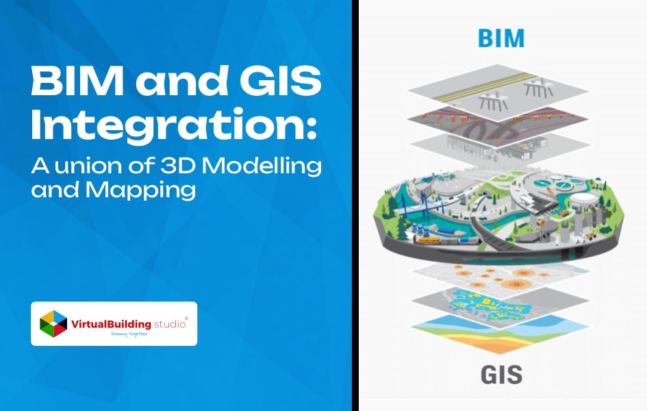
BIM information plays a significant role in the design and construction of a built form while GIS integration provides necessary information for planning and operating various infrastructural projects including roads, railways, airports, bridges, and more, in the context of their surroundings.
GIS adds a layer of geospatial context into the BIM model that elucidates specifications that can influence a structure’s location, construction materials, and building orientation and provides insights about flood-prone areas. This information supports the designing of a smarter and efficient infrastructure.
GIS data operates on a larger scale dealing with cities, regions, and countries while the BIM information applies to small-scale construction. For instance, using BIM data one can design a structure at an object level – detailing a window or a door, while with GIS integration, the structure can be related to a larger context.
It connects a piece of land with utilities and a road network, leading to better designs and an efficient built environment. The combination of these two technologies promotes functioning in a relative context that eliminates data redundancy and reduces overall project expense.
The BIM and GIS generated data is stored in the cloud which can be reused and repurposed by various stakeholders in different contexts without having to convert the data repetitively. The stakeholders of both infrastructural and building projects can manage data in any environment from any part of the world.
Benefits of BIM and GIS Integration for Infrastructural Projects
The integration of BIM and GIS provides manifold benefits to the AEC stakeholders and the construction process as well. The process involves introducing several BIM modeling layers into the geospatial arena. The designers can make precise use of the space with the help of these accurate details about the construction site and its neighborhood.
The GIS-based data facilitates the designing according to the location details which impact the project form, construction techniques, and building materials. Here are a few benefits of using BIM and GIS integration for infrastructural projects:
Multiply Long-Term Cost Savings
The focus during the construction process has shifted towards improving logistics scheduling and reducing time and material wastage, whether general contractors execute prefabrication in a factory or convert the site into an open-air factory.
The comprehensive approach that uses BIM and GIS together adds a spatial dimension to the project, increasing project efficiency.
Improved software interoperability for BIM and GIS in the future will help in developing a project digital twin that enables better designing in context with the actual world. The digital product enables the information to be recorded, indexed, and easily accessed to support successful project completion.
Eliminate Errors and Enhance Accuracy
The cities are facing sustainability and resilience issues that can be resolved by delivering better designs possible with the increased long-term value of infrastructural projects. The optimization of dynamic data interchange between CAD, BIM, and GIS helps in increasing the project value.
The planning and permitting phase of an infrastructural project involves the assessment of social, environmental, and economic impacts.
The project positioning in a real-time urbans cape with GIS integration eliminates the front-end risk of designing and construction. It also saves time invested by engineers and planners in referring to floodplain maps or locating underground utilities.
This collaboration is equally beneficial for long-term purposes after the structure is built. It improves operability and eliminates errors while managing utilities throughout the project lifecycle. The consumers can reuse the data for project maintenance and retrofitting.
Maintain the Closed Data Loop and Eliminate Data Loss
Smart city development requires smart decision-making and efficient design processes, catered to by the significant use of BIM and GIS systems. GIS information incorporates real-time sensor systems, and provides geographical data, and modeling insights, leading to better infrastructure designs of any scale.
For instance, using GIS systems in autonomous vehicles will facilitate real-time data collection with car sensors. The highly accurate machine map used for navigation is a 3D highway design file enriched with real-time data.
These vehicles of tomorrow collect updated data like lane closures or changes due to construction that help in identifying high-risk areas.
This information can be then used by planners designing and maintaining future road networks, leading to a more responsive transportation department and seamless work execution.
Conclusion
BIM and GIS integration will enhance the logistics and efficiency of the AEC industry, along with data exchange optimization. The convergence of two data sets will lead to smarter and more accurate designs responsive to the needs of the future generation.
This collaboration provides an all-around safety of the building and its components. GIS integration provides a comprehensive project picture, enabling better decision-making and resource allocation.
Source: https://www.virtualbuildingstudio.com/bim-and-gis-integration/