


Remodeling Construction Industry with Digitization, BIM and Reality Capture
Digitization of the construction process will significantly reduce risks and enhance bankability of infrastructure projects
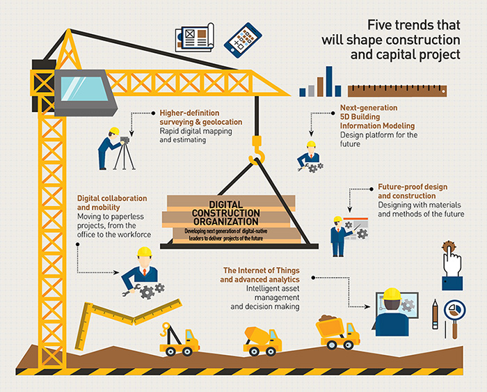

The next-generation BIM
Building Information Modeling (BIM) has been part of the construction industry for some time now. It is the process of designing a building collaboratively using one coherent system of computer models rather than as separate sets of drawings. With continuous technological advancements, next-generation 5D BIM is one of the essential aspects of creating a flawless futuristic construction. However, what is going to revolutionize and has already done in many cases, is the technologies and processes that digitize the whole process by real-time visualization, thereby taking it to the new level.
Agrees Ted Lamboo, Senior Vice President, Strategic Channel, Bentley Systems: “Originally BIM was all about designing a new building right, the process to design in 3D and the process to go from design to construction. BIM in the context of reality, in the context of its environment — the existing roads, infrastructure, vegetation and utilities – and how all that hooks up, is a fantastic additional dimension that enriches processes like BIM to make them better inform processes.”
A very good example to support this is the Crossrail project. Described as Europe’s one of the largest infrastructure construction projects, Crossrail is a 118-km railway line under development in England, running through parts of London and the home counties of Berkshire, Buckinghamshire and Essex. It is supposed to be the most innovative digital engineering project.
Just before it was to start, the project faced a 15-20% funding cut. That’s unique in the infrastructure world, where projects crossing initial budgets are a regular. The only way the project could go ahead was by adopting BIM level III, where a digital twin of the asset and infrastructure was to be created before going into construction. So, before the construction began, a virtual metro line was built. Now, as the project progresses, the models keep on getting updated. These models will also go into operations and maintenance environments, thus making change implementation and maintenance processes much easier.
This is where the world of engineering is changing, says Peter Loeffler, Vice President and Global Head, Trends and Industry Affairs, Siemens Building Technologies. Technologies used in Smart Cities or even individual infrastructure projects/buildings, instantly can evaluate a city’s composition like buildings, vegetation, roads, airport, water, etc. They can also evaluate individual buildings, such as the height of windows, surface areas, and sun exposure. Besides, it can also provide a global traffic model and micro-simulations of specific areas.
“In construction even though the physical aspect is crucial like you need concrete walls, steel beams, etc. but how you plan that can be improved. In order to streamline the construction process you need digital components. The next big step will be off the construction, i.e. running a building,” he explains.
Today, a lot of things are still done manually. In the future, important assets will tell a Cloud-based system about their health and about their state, and then different things can be done in terms of services — not only time and material services, but predictive and prescriptive services. “Maybe things can in future heal themselves or may be a robot will go there and change it. The future will be different from the today’s present. We will see those digital changes everywhere and also in the building industry,” he adds.
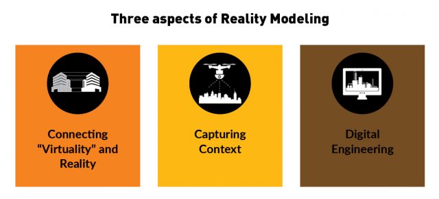
What is digital engineering and reality mesh?
Digital engineering is the process that delivers an integrated set of geometric model data and documentation that builds over the life of a project capturing all knowledge related to a particular asset during the design manufacturing construction and the asset management phases. In the process it provides a collaborative environment for all project stakeholders, enabling innovative solutions to be identified, and developed and rapidly validated.
A reality mesh, on the other hand, is the combination of real and virtual worlds that produces new environment and visualization. In a reality mesh, physical and digital objects meet and interact in real time to help professionals plan, design, construct and operate projects better.
Lamboo makes it simpler: For the past couple of decades engineering was taking an empty piece of paper and designed whatever was required. Then the teams went into the fields and tried applying those designs on the new constructions that were being planned. Reality mesh or reality modeling refers to capturing the existing situation first and putting the newly designed infrastructure that you plan in the context of the existing reality. “You get the reality of today and the design of tomorrow together, and then the resulting outcome is the reality of tomorrow,” adds Lamboo.
Reality mesh is the capture of the current situation; this capture can be done with drones, satellites, scanners, even with iPhones by taking pictures, and the engineering data is then inserted on top of it. Engineering-ready reality meshes can help in managing maintenance records or ownership records.
“There is an increasing effort being made to turn the construction process into a manufacturing process,” says Chris Gibson, Senior Vice President, Trimble, USA. This work process and the data flow is being streamlined so that people can collaborate in the same model and understand exactly what is going on so that one can drive that down into a 5D virtual construction. “As an owner or contractor, you are getting almost real-time information on the changes in the overall project based on the changes that you are making upstream in the process,” he adds.
For instance, Bentley’s Context Capture generates the reality model. The model’s data type is a mesh. “That means in that output you have the triangulated meshes, you have the texuarization of what you see like the façade of a building, picture of the trees, etc,” Lamboo adds. But behind it is also the point cloud that you can generate. So the process of making photos of different elevations and type combining with scanned data and creating a reality model.
Is the construction industry ready for the change?
The good news is large organizations are taking to some of the new capabilities and technologies pretty quickly, and a fair amount of adoption and penetration are beginning to take off. These organizations have been running numerous pilots around the world.
Jason Hutchings, Senior Director, Atkins, Hong Kong, gives a good example of how virtual world was used in a construction site to make the whole process simple and accurate: “A project in Hong Kong that was under construction and there was a requirement to check whether the rivets were placed appropriately. So, they did a LiDAR scan of the as-built condition and cross-checked the rivet model from which the contact was built and identified whether rivets were put in the right place or bolts had been tightened up.” The degree of resolution can help the construction industry retrospectively as well as proactively through the assembly process. “We are already there in many cases. It is the question of the application of that technology and getting into the right environment.”
Hutchings thinks that the industry is in the transition phase: “Design is typically a process and as we transition into a world of BIM and accurate modelling, there is an investment of time in doing that. I think we are in a transitional stage within the industry. Some people have jumped in harder and failed quickly, which is also a good thing to do, but we need to remember that as a community we need to somehow educate ourselves how to work together differently to be able to embrace the technologies and the information available.”
What is driving the adoption?
To start with, lightweight, cost-effective equipment is making the impact. Noteworthy advancements in the laser scanning hardware has made the adoption of reality capture process easier. For example, scanning hardware in last 10 years reveals significant change in the trend. A scanner in 2007 was about $80,000 each and need a whole team to carry it around. But now, hardware and software partners are launching lightweight scanners. These devices are so light and small that anyone could slip them in a backpack, go to a site, start scanning, and immediately begin processing scan data using mobile software. Similarly UAVs have drastically reduced the cost of scanning a site. While it would earlier take about $40,000 to do a one-time scan of a site by a professional company or LiDAR-equipped plane, now the same job can be done by owning a commercial drone starting at $1,500.
From the software side, software packages have increased functionality at a fraction of the price and made much easier. For example, a product which does 3D city model creation, can now run it as a Cloud service. So if you are a user and want the data, then you can put your photos or point clouds together, upload them on the website and it processes everything and sends it back to you, making the whole process simple.
Specialized technology providers offer cost-efficient survey packages, including drone and UAV equipment, data uploading, and processing services, as well as software to manage drone flights, data capture, and dashboards to visualize information. Some government agencies and nongovernmental organizations have started providing free LiDAR maps.
The next step would be tools that can make it faster and more away from the hands of experts. The traditional world of photogrammetry needed someone who understood the software and science. On the other hand, in automated processing like creating 3D buildings or 3D city models, maybe just 10% of human intervention is required, the rest of being taken care of by computer vision, machine learning and lot of other algorithms.
Another technology which is heavily helping adoption of reality capture is Internet of Things. Sensors and wireless technologies enable equipment and assets to become “intelligent” by connecting them with one another. On a construction site, IoT allows construction machinery, equipment, materials, structures, and even formwork to “talk” to a central data platform to capture critical performance parameters. Sensors, near-field communication (NFC) devices, and other technologies can help monitor productivity and reliability of both staff and assets.
Challenges in the way
There are a few hurdles hindering the adoption of these niche technologies.
1. Lack of collaboration and seamless data flow: A major challenge is an inability to achieve greater collaboration and seamless data flow. Agrees Gibson, “A large construction engineering organization may operate with 30 or 40 different applications in their organization, but the challenge for them is how seamlessly they can migrate the data from one application to another.” This issue can be solved with effective collaboration at every level.
A very good example of a successful collaboration could be a construction firm working with a software company to build a predictive analytics engine to prevent equipment breakdowns on-site for its fleet of construction vehicles. This could save millions of dollars in downtime, fuel costs, and maintenance expenses.
2. Accessible and simple tools: Easy accessibility and operability of equipment is also a major factor. User-friendly tools are the buzzwords here. For the design and construction industry, a true Scan-to-BIM workflow will get you from push-button scan to deployable BIM model in a few hours. With no previous experience, any industry professional can navigate the workflow because of its user-friendly nature. As Andreas Gerster, Vice President BIM/CIM and Product Design, FARO, Germany explains, “Construction is all about measurement. Traditionally, there were dedicated professionals or surveyors. These people where the only ones who would know about measuring and would keep the art as a secret. So one of the challenges is definitely to democratize.”
Agrees Johannes Riegl Jr, Chief Marketing Officer, Riegl, Austria, while emphasizing that the tools must be made user friendly. “All that matters to a customer is productivity. So, we need to provide them the equipment and review the existing workflow with them. The tools must empower them to make changes to their existing workflows and speed up the process.” Sometimes this is a challenging task as this takes a while to really prove that technology is worth the investment. It is also critical that the user in the field does not require a surveying degree or any specialized degree to handle these tools.
3. Cost-effective solutions: Technologies like reality mesh and digital engineering are expensive. This limits their adoption. While there are a plenty of success stories in the developed world where these technologies have made an impact, there are very few examples in the developing countries. The challenge is not only to make these technologies cost-effective but to make them available to masses or workers who are mostly illiterate or less literate in the developing countries.
Hutchings thinks one of the answers lies in use of smartphones. Smartphones have the potential to reach the masses irrespective of which country they belong to. “Using smart phones you can track journey time. So, this mega data can be used to improve the way in which we design. You can also take photographs and scan. May be 10 years down the line, mobile devices are completely going to change the industry.”
4. Connecting with the right users: While technological innovations have given an impetus to the construction and digital engineering world, these innovations need to be adopted by the right professionals to get appropriate results. As Brian Nicholls, Executive Director, AAM Group, Australia, points, “As a surveying and mapping company we understand this technology very well. But do the guys on the other side know us? I recently bought a book on BIM. In the entire book, the word GIS is mentioned only twice and the word laser scanning only once.” No wonder at conferences of civil engineers they hardly talk about digital engineering. “So I think that as a mapping spatial technologist we are still not always connecting with the professions that actually we have to interact with.”
Bridging the gap
This leads to the question: Is there a disconnect between the companies and the customers that they serve?
Nicholls thinks that although this disconnect majorly depends on case to case, but this trend of large disconnect mostly prevails.
Gibson points out that this trend allows and enables significant amount of collaboration to take place effectively. “The challenge we have amongst ourselves is to ensure that we have the connectivity and interoperability between our various applications because the process in terms of engineering construction is complex.” Some of the big players around the world may well be having 30 or 40 different applications that this data is flowing through — it is not just about interfacing around the geospatial engineering aspects, it is going into their ERP systems, Oracle or SAP systems or project management systems — and at the moment it’s very difficult for them to get a seamless flow of data. Customers care less about how you get the answer than that the answer is correct and going to help solve their problem. So, those touch points are significant and this is part of the ongoing challenge and future that we have to create.”
Reality capture is the future
Fields like architecture and engineering are always evolving. So, what technology and digital platforms are allowing us to do is probably do more than we had previously done. As Hutching says, “We are all embracing technology as fast as we can. We recognize that we can do more and we can do it quicker but there are dangers to be aware of as well.”
The benefits of new technological innovations outweigh the challenges. So, the industry needs to gear up and adopt the technologies as soon as possible. To be more productive, construction has to move from being a conceptual model to a constructible model, and this is where technologies like augmented reality or mixed reality will play a big role in enabling the digital engineering process.
Along with this, new building materials, such as self-healing concrete, aerogels, and nanomaterials, as well as innovative construction approaches, such as 3D printing and preassembled modules, can lower costs and speed up construction while improving quality and safety.
Fusion of the real and digital worlds provides the user with immersive virtual experience. Will this hybrid be the future of BIM? The future will only tell.